Kalindi Khal Pass (5,950 M)

Home / Expeditions / Kalindi pass
Kalindi Pass Expedition
  • Kalindi Khal Pass
  • situated in the north india's gangotri glacier.
  • elevation 5,950 mtr from sea level

Overview

Price

₹1,04,499

Duration

13N / 14D

Region

Uttarakhand

Pick & Drop

Uttarkashi – Rishikesh

Best Time

May, June, Sep, Oct

Trekking

86 KM

Route

Uttarkashi – Gangotri – Bhojwasa – Nandanvan – Khada Pathar – Sweta Glacier - Kalindi Khal - Raja Parav -Badrinath - Rishikesh

Certified Guide

Certified and experienced mountaineering guides / sharpa.

Safety

Strict safety protocols, trained staff, and secure expedition experience.

Kalindi Khal Pass: Conquering a Majestic High-Altitude Pass
···—

Kalindi Khal Pass is a spectacular high-altitude mountain pass located in the state of Uttarakhand. It forms a remote link between the holy town of Gangotri and the sacred site of Badrinath. Situated at an impressive altitude of 5,950 meters (19,520 feet) above sea level, it is one of the most challenging and highest trekking passes in the Indian Himalayas.

Trekking Route and Terrain

The trek to Kalindi Khal Pass is long, arduous, and technically very demanding. Trekkers have to navigate vast glaciers, unstable moraines, boulder-strewn paths, and steep rocky sections. The entire journey typically takes about two weeks, testing both endurance and mental fortitude at every stage.


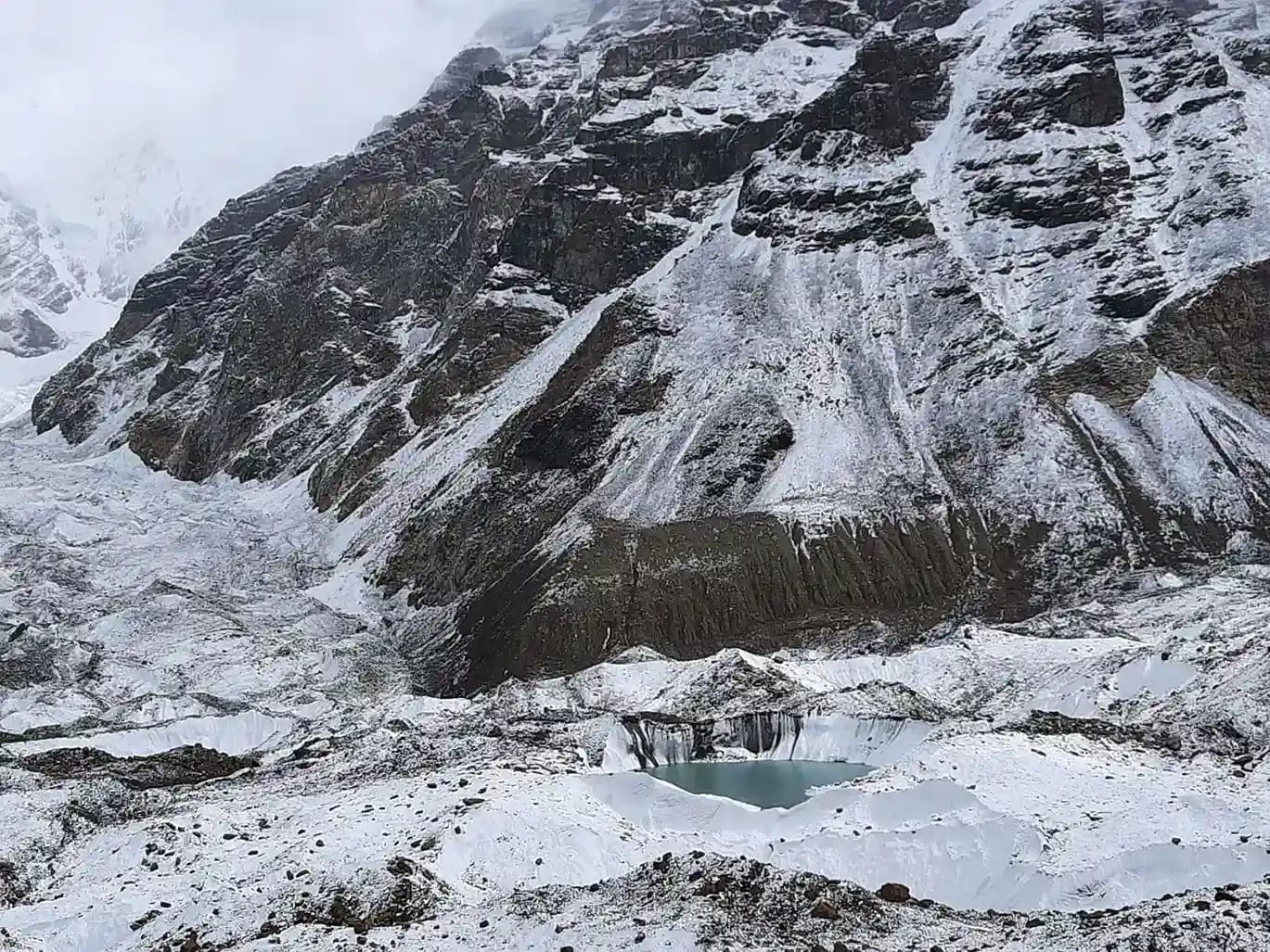
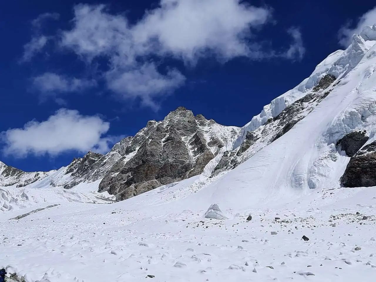
Natural Beauty Along the Way

Despite its difficulty, this trek rewards adventurers with extraordinary natural beauty. Along the way, trekkers witness breathtaking views of snow-capped Himalayan peaks, pristine alpine lakes, and vast glaciers stretching across the landscape. The untouched wilderness adds a sense of solitude and true adventure to the journey.

Why the Pass is Called Kalindi

The pass is named after the Kalindi River, which originates from the snout of the Gangotri Glacier. This river later merges with the Alaknanda River near Mana village. The region is significant both geographically and spiritually, deeply connected to the Himalayan river systems.


Difficulty Level and Preparation

Kalindi Khal Pass is considered a very challenging trek. It involves snow-covered trails, steep ascents, glacier crossings, and high-altitude exposure. Successfully completing it requires excellent physical fitness, prior high-altitude trekking experience, basic mountaineering skills, and appropriate technical gear. The Surrounding Himalayan Peaks

From close quarters, trekkers are treated to breathtaking views of some of the most iconic Himalayan giants, such as Shivling, Meru, and Bhagirathi III. These towering peaks form a magnificent backdrop that leaves a lasting impression on every adventurer.

Kalindi Khal Pass is a dream destination for experienced trekkers, mountaineers, and adventure enthusiasts seeking an adrenaline-pumping experience in the heart of the Himalayas.

Gallery

···—

Inclusions:-

···—

1. Accommodation. (Guest house/Camping)

Exclusions:-

···—

1. Any kind of personal expenses.
2. Food during the transit.
3. Insurance
4. Mules or porter to carry personal luggage.
5. Anything not specifically mentioned under the head.
6. Any kind of emergency evacuation charges.

Note : Charges of offloading backpack:- INR 8000/- The backpack cannot weigh more
than 10 kgs.

Why Choose Us 

···—

☑️ Recognised by Government of India.
☑️ Special focus on safety.
☑️ Local knowledge and experience.
☑️ Friendly and kind staff.
☑️ High operating equipment.
☑️ Value of time and money.
☑️ Guarantee foxed departures.
☑️ Save time and effort.

Cancellation Policy

···—

Cancellations prior to 30 days from the start of the Trip

a. Get 95% refund
B. 100% cash voucher for any trip till one year

Cancellation between 30 days and 15 days to the start of the Trip

• Get 70% cash refund
• 100% cash voucher for same trip till one year
• 80% cash voucher for any trip till one year

Cancellation less than 15 days to the start of the trek

• No refund

Trip Itinerary

1

Day 1: Arrival at Uttarkashi

Arrive at Uttarkashi, a quiet Himalayan town on the banks of the Bhagirathi River. The day is reserved for rest and preparation. In the evening, meet the expedition leader for a detailed briefing, gear inspection, and discussion about altitude safety and trek protocols. Stay: Hotel

Elevation: +1,158m Distance: 2-3km
2

Day 2: Uttarkashi to Gangotri

A scenic drive of about 100 km (6-7 hours) through the beautiful Harsil Valley. The landscape gradually changes from forested slopes to rugged Himalayan terrain. Upon reaching Gangotri, the spiritual starting point of the expedition, the evening is kept relaxed to help the body adjust to the sudden gain in altitude. Stay: Hotel

Elevation: 1,158m +3,048m Distance: 100km
3

Day 3: Gangotri – Acclimatization & Local Exploration

This is a crucial acclimatization day. Short walks around Gangotri help the body adapt to thinner air. Trekkers can visit the Gangotri Temple and explore the surroundings while enjoying views of the Bhagirathi peaks. Rest and hydration are emphasized throughout the day. Stay: Hotel

Elevation: +3,048m Distance: 4-5km
4

Day 4: Gangotri to Bhojwasa

The trek officially begins today, following a well-defined trail along the Bhagirathi River. The route offers constant views of the Gangotri Glacier and surrounding peaks. The terrain gradually becomes rocky as you approach Bhojwasa, a windswept campsite near the glacier. Stay: Tents

Elevation: 3,048m / +3,784m Distance: 14km
5

Day 5: Bhojwasa to Tapovan (via Gaumukh)

Today’s highlight is crossing Gaumukh, the sacred snout of the Gangotri Glacier. From here, the climb to Tapovan becomes steeper, rewarding trekkers with spectacular views of towering Himalayan peaks. Tapovan’s open meadows provide a dramatic and inspiring campsite. Stay: Tents

Elevation: 3,784m / +4,463m Distance: 13km
6

Day 6 : Tapovan to Vasuki Tal (via Nandanvan)

The trail moves across rocky sections and glacial terrain. This day involves crossing the challenging Chaturanga Glacier, requiring careful navigation. The trek ends at Vasuki Tal, a serene high-altitude lake set in a stark, icy landscape. The thin air and isolation make this camp truly unforgettable. Stay: Tents

Elevation: 4,463m / +4,880m Distance: 12km
7

Day 7: Vasuki Tal to Khara Pathar / Suralya Bamak

The ascent becomes steeper as you move higher into the glacial zone. Snowfields, moraines, and exposed sections dominate the route. This is one of the more physically demanding days of the expedition. Stay: Tents

Elevation: 4,880m +5,480m Distance: 3-4km
8

Day 8: Khara Pathar to Sweta Glacier

Though the distance is short, the terrain is technical and slow-moving. Trekkers negotiate snow-covered slopes and glacier sections while constantly monitoring weather and conditions. Stay: Tents

Elevation: 5,480m / +5,500m Distance: 4-5km
9

Day 9: Sweta Glacier to Kalindi Khal Base Camp

A steady climb leads to Kalindi Khal Base Camp. The rest of the day is spent resting, hydrating, and preparing equipment for the summit crossing. Early dinner and proper rest are essential. Stay: Tents

Elevation: 5,500m +5,600m Distance: 4-5km
10

Day 10: Base Camp → Kalindi Khal Pass → Raja Parav

The most challenging and rewarding day of the expedition. An early start is required to cross Kalindi Khal Pass before weather conditions change. The ascent is steep and technical, followed by a long descent to Raja Parav. Reaching this campsite marks the successful completion of the pass crossing. Stay: Tents

Elevation: 5,600,m +5,950m -4,910m Distance: 13km
11

Day 11: Raja Parav to Arwa Tal

The route descends gradually through rocky valleys and glacial streams. Arwa Tal, a beautiful alpine lake, offers a peaceful and well-earned campsite after the intensity of the previous day. Stay: Tents

Elevation: 4,910m -3,910m Distance: 14km
12

Day 12: Arwa Tal to Ghastoli

A long but easier day as the trail continues downhill into greener terrain. The sense of civilization slowly returns as you approach Ghastoli village. Stay: Hotel

Elevation: 3,910m -3,796m Distance: 16km
13

Day 13: Ghastoli to Mana Village to Badrinath

The trek ends at Mana, India’s last village near the Tibetan border. A short drive brings you to Badrinath, where trekkers can relax and reflect on the expedition. Stay: Hotel

Elevation: 3,796m - 3,096m Distance: 18km
14

Day 14: Badrinath to Rishikesh (via Joshimath)

Departure day. The journey back offers time to revisit memories of one of the most demanding and rewarding high-altitude treks in the Indian Himalayas.

Elevation: 3,096m -409m Distance: 222km

Experience

Booking Form

Kalindi Khal Pass with Great Adventure Gangotri

Contact us for planning your Kalindi Khal Pass with best travel packages of as per your requirements!

INTERNATIONAL  AND NATIONAL MEMBERSHIP 

Recognised by Ministry of Tourism, Government of India as Inbound tour operator & Adventure tour operator. Registered  with Indian Mountaineering Foundation. ( IMF )

Contact Us

Get Direction Here

Scroll to Top